Application of GIS and remote sensing for advancing sustainable fisheries management in Southeast Asia
Share
Abstract
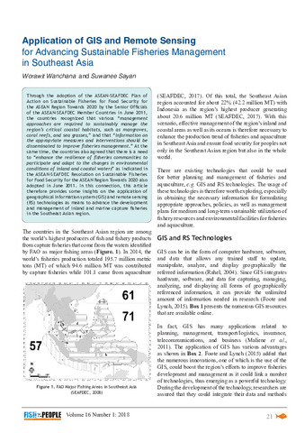
Through the adoption of the ASEAN-SEAFDEC Plan of Action on Sustainable Fisheries for Food Security for the ASEAN Region Towards 2020 by the Senior Officials of the ASEAN-SEAFDEC Member Countries in June 2011, the countries recognized that various “management approaches are required to sustainably manage the region’s critical coastal habitats, such as mangroves, coral reefs, and sea grasses,” and that “information on the appropriate measures and interventions should be disseminated to improve fisheries management.” At the same time, the countries also agreed that there is a need to “enhance the resilience of fisheries communities to participate and adapt to the changes in environmental conditions of inland and coastal waters” as indicated in the ASEAN-SEAFDEC Resolution on Sustainable Fisheries for Food Security for the ASEAN Region Towards 2020 also adopted in June 2011. In this connection, this article therefore provides some insights on the application of geographical information system (GIS) and remote sensing (RS) technologies as means to advance the development and management of inland and marine capture fisheries in the Southeast Asian region.
Suggested Citation
Wanchana, W., & Sayan, S. (2018). Application of GIS and remote sensing for advancing sustainable fisheries management in Southeast Asia. Fish for the People , 16(1), 21-28. http://hdl.handle.net/20.500.12066/1357
Subject
Collections
Related items
Showing items related by title, author, creator and subject.
-
Training and Study Tour
(Training Department, Southeast Asian Fisheries Development Center, 2007)Training course and study tour formed part of Activity IV: Enhance Human Resource Capability and Participation of the project on Integrated Coastal Resource Management in Pathew District (ICRM-PD). The subjects and topics ... -
Marine Environments and Phytoplankton in the Area of the Locally Based Coastal Fisheries Management Project: Pathew District, Chumphon Province
(Training Department, Southeast Asian Fisheries Development Center, 2007)Investigations on marine environments were carried out at 10 sampling stations in the area of the Locally-Based Coastal Fisheries Management Project, Pathew District, Chumphon Province from 2002 to 2006. The depth of the ... -
Women's Group Development: Integrated Coastal Resources Management in Pathew District (ICRM-PD), Chumphon Province
(Training Department, Southeast Asian Fisheries Development Center, 2007)The Integrated Coastal Resources Management Project (ICRM-PD) was established in Pathew District, Chumphon Province, on 9 November 2001 as a collaborative effort between SEAFDEC/TD and the DOF of Thailand. The project aims ...