Practical techniques for mapping small patches of mangroves
Share
Abstract
Practical mapping methods employing GPS field surveys and manual image analyses with affordable software were used to assess two mangrove sites in Aklan Province, NE Panay Island, central Philippines. The Jawili mangroves, absent from current maps, actually included 21.5 ha with 24 true mangrove species. On the other hand, the Batan Estuary mangroves, shown to be 4244 ha in available topographic maps, revealed only 406 ha of scattered patches. Actual mangrove data on specific areas worldwide is limited, especially in the Philippines where available maps show discrepancies from actual mangrove distribution. Remote sensing (RS) techniques provide promising results but require expensive setup, particularly for small areas. Therefore, financially limited users need affordable and rapid mapping alternatives. The practical techniques presented here can be immediately implemented at minimal cost and can produce useful estimates of actual mangrove area, fundamental for coastal management. Basic principles used here also have potential applications in other systems and locations. When resources are available though, additional confirmation and precise mapping are also further recommended.
Suggested Citation
Altamirano, J., Primavera, J., Banaticla, M. R. N., & Kurokura, H. (2010). Practical techniques for mapping small patches of mangroves. Wetlands Ecology and Management , 18(6), 707-715. https://doi.org/10.1007/s11273-010-9190-2
Subject
topographic maps; estuaries; mapping; remote sensing; wetlands; manuals; GIS; aerial photographs; patchiness; management; mangroves; coastal zone management; ecosystems; computer programs; computer software; data processing; islands; image processing; costs; surveys; maps; mangrove swamps; Digitized map; GPS tracking; Philippine mangroves; Rapid assessment; Patterns; Ikonos; Coast; Philippines
Collections
- AQD Journal Articles [1249]
Related items
Showing items related by title, author, creator and subject.
-
Mapping gendered spaces for sandfish resource management in Guimaras, Philippines
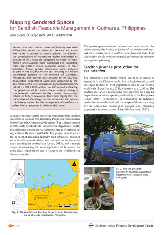
(Secretariat, Southeast Asian Fisheries Development Center, 2018)Women and men utilize spaces differently and have differential access to resources because of norms and values attached to certain places. In fisheries, the contributions of women are either overlooked or considered less ... -
Quantitative trait Locus Mapping of Growth‐related Traits in Inter‐specific F1 Hybrid Grouper (Epinephelus fuscoguttatus x E. lanceolatus) in a tropical climate
(Wiley, 2017)Growth‐related traits are the main target of genetic breeding programmes in grouper aquaculture. We constructed genetic linkage maps for tiger grouper (Epinephelus fuscoguttatus) and giant grouper (E. lanceolatus) using ... -
Phytoplankton distribution mapping using NOAA AVHRR satellite data
(Marine Fishery Resources Development and Management Department, Southeast Asian Fisheries Development Center, 1999)